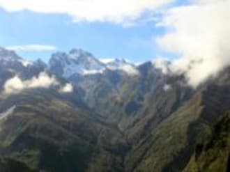
Open Stage Haast Tahr
Only one application per party, minimum of 2, maximum of 6 hunters will be accepted.
**Applications not containing all party members names and dates of birth will be considered invalid**
(02) Upper Zora
(03) Opposite Percy
(04) Hinds Tarn
(05) Shelter Hollow
(06) Arbor Rift
(11) Dechen Creek
- period 1 - Saturday 27 April to Friday 03 May
- period 2 - Saturday 04 May to Friday 10 May
- period 3 - Saturday 11 May to Friday 17 May
- period 4 - Saturday 18 May to Friday 24 May
- period 5 - Saturday 25 May to Friday 31 May
- period 6 - Saturday 01 June to Friday 07 June
- period 7 - Saturday 08 June to Friday 14 June
- period 8 - Saturday 15 June to Friday 21 June
- period 9 - Saturday 22 June to Friday 28 June
Any currency conversion from NZD will be indicative only
| Package Rate (min stay) |
Sat 20 Apr |
Sun 21 Apr |
Mon 22 Apr |
Tue 23 Apr |
Wed 24 Apr |
Thu 25 Apr |
Fri 26 Apr |
Sat 27 Apr |
Sun 28 Apr |
Mon 29 Apr |
Tue 30 Apr |
Wed 01 May |
Thu 02 May |
Fri 03 May |
Sat 04 May |
Sun 05 May |
Mon 06 May |
Tue 07 May |
Wed 08 May |
Thu 09 May |
Fri 10 May |
Sat 11 May |
Sun 12 May |
Mon 13 May |
Tue 14 May |
Wed 15 May |
Thu 16 May |
Fri 17 May |
Sat 18 May |
Sun 19 May |
Mon 20 May |
Tue 21 May |
Wed 22 May |
Thu 23 May |
Fri 24 May |
Sat 25 May |
Sun 26 May |
Mon 27 May |
Tue 28 May |
Wed 29 May |
Thu 30 May |
Fri 31 May |
Sat 01 Jun |
Sun 02 Jun |
Mon 03 Jun |
Tue 04 Jun |
Wed 05 Jun |
Thu 06 Jun |
Fri 07 Jun |
Sat 08 Jun |
Sun 09 Jun |
Mon 10 Jun |
Tue 11 Jun |
Wed 12 Jun |
Thu 13 Jun |
Fri 14 Jun |
Sat 15 Jun |
Sun 16 Jun |
Mon 17 Jun |
Tue 18 Jun |
Wed 19 Jun |
Thu 20 Jun |
Fri 21 Jun |
|---|---|---|---|---|---|---|---|---|---|---|---|---|---|---|---|---|---|---|---|---|---|---|---|---|---|---|---|---|---|---|---|---|---|---|---|---|---|---|---|---|---|---|---|---|---|---|---|---|---|---|---|---|---|---|---|---|---|---|---|---|---|---|---|
(01) Baker Creek Lower — Weekly Permit (1 night min)Very popular and productive area. Most creek systems holding tahr, but steep to access. Good sheltered campsite options. Nice upper basin with rock bivvy (Baker Creek) in good weather conditions. Suitable for hunting parties of 4 persons. River/creek water supply.
Access information
Helicopter access: Restricted to two designated landing sites only during ballot period. Baker Creek landing site: NZTM2000 E1344828-N5144719 Alternative Upper Baker landing site: NZTM2000 E1346308-N5142874 Road access point: Karangarua or Landsborough. Foot access: It is possible to walk in from outside the wilderness area boundary at Kea Flat Block specific information Permissions: DOC hunting permit required Map: Topo50 BY14 Hooker-Landsborough landing sites (JPG, 1084K) (opens in new window) |
|||||||||||||||||||||||||||||||||||||||||||||||||||||||||||||||
(02) Upper Zora — Weekly Permit (1 night min)Large campsite, but can be very exposed in bad weather. Reasonable foot access around most of area. Tahr on both sides of Zora Creek. Suitable for parties of 4 hunters. Creek water supply.
Access information
Helicopter access: Restricted to designated landing site only during ballot period Landing site: NZTM2000 E1344552-N5147269 Road access point: Karangarua or Landsborough Foot access: Very difficult, several days walk Site specific information Permissions: DOC hunting permit required Map: Topo50 BY14 Hooker-Landsborough landing sites (JPG, 1084K) (opens in new window) |
|||||||||||||||||||||||||||||||||||||||||||||||||||||||||||||||
(03) Opposite Percy — Weekly Permit (1 night min)Access up creeks to the tops. In low flow, the river can be crossed. Suitable for parties of 2-3 hunters. River water supply.
Access information
Helicopter access: Restricted to designated landing site only during ballot period. Landing site: NZTM2000 E1346649-N5145441 Road access point: Landsborough road end. Foot access: Very difficult. Site specific information Permissions: DOC hunting permit required Map: Topo50 BY14 Hooker-Landsborough landing sites (JPG, 1084K) (opens in new window) |
|||||||||||||||||||||||||||||||||||||||||||||||||||||||||||||||
(04) Hinds Tarn — Weekly Permit (1 night min)Exposed campsite. Limited area to hunt, but very scenic. Tarn water supply. Suitable for small hunting parties (2 persons).
Access information
Helicopter access: Restricted to designated landing site only during ballot period. Landing site: NZTM2000 E1344480-N5145629 Road access point: Landsborough road end. Foot access: Very difficult. Site specific information Permissions: DOC hunting permit required Map: Topo50 BY14 Hooker-Landsborough landing sites (JPG, 1084K) (opens in new window) |
|||||||||||||||||||||||||||||||||||||||||||||||||||||||||||||||
(05) Shelter Hollow — Weekly Permit (1 night min)Sheltered campsite in the trees. Good creek access to the tops. Generally lots of tahr living in bush. Suitable for parties of 4. Creek water supply.
Access information
Helicopter access: Restricted to designated landing site only during ballot period Landing site: NZTM2000 E1349017-N5147575 Road access point: Karangarua or Landsborough Foot access: Very difficult, but possible from Kea Flat Block specific information Permissions: DOC hunting permit required Map: Topo50 BY15 Hooker-Landsborough landing sites (JPG, 1084K) (opens in new window) |
|||||||||||||||||||||||||||||||||||||||||||||||||||||||||||||||
(06) Arbor Rift — Weekly Permit (1 night min)Nice, sheltered campsite under the trees. Limited tent space. Access around block pretty good although upper slopes very steep. Suitable for parties of 4. River/creek water supply.
Access information
Helicopter access: Restricted to the designated landing site only during ballot period. Landing site: NZTM2000 E1348833-N5147579 Road access point: Karangarua or Landsborough. Foot access: Very difficult, from Kea Flat one long day. Site specific information Permissions: DOC hunting permit required Map: Topo50 BY15 Hooker-Landsborough landing sites (JPG, 1084K) (opens in new window) |
|||||||||||||||||||||||||||||||||||||||||||||||||||||||||||||||
(07) Mahitahi Lower — Weekly Permit (1 night min)Mahitahi: Sheltered camps with space for two tents. Scrubby country with creek access. Suitable for groups of 4 hunters. Creek water supply.
Mahitahi Upper: Exposed camp higher up the valley. Easy hunting access. Suitable for groups of 4. Creek water supply.
Tahr found throughout, with highest numbers on the upper true left. Popular area during ballot period.
Access information
Helicopter access: Restricted to designated landing site only during ballot period Mahitahi landing site: NZTM2000 E1340802-N5151054 Alternative Mahitahi Upper landing site: NZTM2000 E1342807-N5149954 Road access point: Mahitahi or Landsborough Foot access: 2-3 days walk from SH6 Site specific information Permissions: DOC hunting permit required Map: Topo50 BY14 Hooker-Landsborough landing sites (JPG, 1084K) (opens in new window) |
|||||||||||||||||||||||||||||||||||||||||||||||||||||||||||||||
(08) Edison River — Weekly Permit (1 night min)Camp in the gully by the creek. This site is at a higher altitude, and can be very cold. Large flat area for camping. Suitable for parties of 4 hunters. Creek water supply.
Access information
Helicopter access: Restricted to designated landing site only during ballot period. Landing site: NZTM2000 E1339072-N5148289 Road access point: Mahitahi road end (State Highway 6). Foot access: Very difficult. Access via Mahitahi and Edison river valleys. Site specific information Permissions: DOC hunting permit required Map: Topo50 BY14 Hooker-Landsborough landing sites (JPG, 1084K) (opens in new window) |
|||||||||||||||||||||||||||||||||||||||||||||||||||||||||||||||
(09) Jacobs Upper — Weekly Permit (1 night min)Jacobs Upper: Large, open and exposed campsite. Scrubby country but with good access. Suitable for groups of 4 hunters. Creek water supply.
Jacobs Lower: Large, exposed, flat camp. Scrubby country with limited hunting options. Suitable for parties of 2. River water supply.
Tahr found throughout, with highest numbers on the upper true left. Popular area during ballot period.
Access information
Helicopter access: Restricted to two designated landing sites only during ballot period Jacobs Upper Landing site: NZTM2000 E1343272-N5154505 Alternative Jacobs Lower Landing site: NZTM2000 E1341012-N5155874 Road access point: Jacobs River (SH 6) Foot access: 2-3 days walk from SH6 Site specific information Permissions: DOC hunting permit required Map: Topo50 BX14 Hooker-Landsborough landing sites (JPG, 1084K) (opens in new window) |
|||||||||||||||||||||||||||||||||||||||||||||||||||||||||||||||
(10) Upper Otoko — Weekly Permit (1 night min)Good sheltered camp. Access up creeks through the scrub. Tahr usually up high. Creek/river water source. Suitable for parties of 4.
Access information
Helicopter access: Restricted to designated landing site only during ballot period. Landing site: NZTM2000 E1333584-N5144470 Road access point: Paringa road end. Foot access: Very difficult. Access via the Paringa and Otoko river valleys. Site specific information Permissions: DOC hunting permit required Map: Topo50 BY14 Hooker-Landsborough landing sites (JPG, 1084K) (opens in new window) |
|||||||||||||||||||||||||||||||||||||||||||||||||||||||||||||||
(11) Dechen Creek — Weekly Permit (1 night min)Large open camp. Access to tops via ridges. Creeks very steep. Suitable for parties of 4 hunters. Creek water supply.
Access information
Helicopter access: Restricted to designated landing site only during ballot period. Landing site: NZTM2000 E1341760-N5142340 Road access point: Landsborough road end. Foot access: Very difficult. Site specific information Permissions: DOC hunting permit required Map: Topo50 BY14 Hooker-Landsborough landing sites (JPG, 1084K) (opens in new window) |
|||||||||||||||||||||||||||||||||||||||||||||||||||||||||||||||
(12) Bubble Creek — Weekly Permit (1 night min)Nice flat campsite. East tops access on both sides of the river. River water supply. Campsite suitable for parties of 4 hunters.
Access information
Helicopter access: Restricted to designated landing site only during ballot period. Landing site: NZTM2000 E1351830-N5150004 Road access point: Landsborough or Karangarua road end. Foot access: Very difficult. Site specific information Permissions: DOC hunting permit required Map:Topo50 BY15 Hooker-Landsborough landing sites (JPG, 1084K) (opens in new window) |
|||||||||||||||||||||||||||||||||||||||||||||||||||||||||||||||
(Adams1) Adams Flat — Weekly Permit (1 night min)Most tahr are predominately scrub dwellers. Highest tahr numbers on faces opposite Adams Flat and above the bushline on the true right of Eblis Gorge and true right Alpheus Creek, the true left of Athene Creek, and at the head of Boulderpool Creek. Low deer numbers, mainly downstream of Eblis Gorge. Good chance to see a deer/chamois down along the faces of Speculation Range.
Large camp on river flats. Good access to hunting, some scrub lower down but clear slips and creeks. Suitable for 4 hunters. River water supply.
Access information
Helicopter access: Restricted to designated landing site only during ballot period. Landing site: NZTM2000 E1412314-N5205900 Road access point: Wanganui road end. Foot access: Very difficult. River access problems in Eblis /Adams River Gorge from Hunters Hut. Site specific information Permissions: DOC hunting permit required Map: Topo50 BW17 Additional species: Chamois and red deer Adams Landing Sites (JPG, 1140K) (opens in new window) |
|||||||||||||||||||||||||||||||||||||||||||||||||||||||||||||||
(Adams2) Lord River — Weekly Permit (1 night min)Best tahr hunting is along scrub/bush-line. If weather allows then hunters should consider camping above the bush-line. Good tahr numbers around Devastation Creek, Crumbling Spur and Poker Gully. Good numbers of chamois also present, especially around Blue Lookout.
Lord River campsite: Large campsite. Lots of open country to hunt - suitable for groups of 4 hunters. River water supply.
Lord Range alternative campsite: Campsite on exposed tussock knob. High camp in good hunting and glassing country. Suitable for small groups of 2-3 hunters. Tarn water supply in close proximity.
Access information
Helicopter access: Available all year except outside of the Adams Wilderness Area boundary. Restricted to two designated landing sites only during the ballot period within the boundary. Lord River landing site: NZTM2000 E1423272-N5208058 Alternative Lord Range landing site: NZTM2000 E1421807-N5208091 Road access point: Wanganui road end. Foot access: Difficult. Via the Wanganui river valley and Hunters or Smyth huts. Site specific information Permissions: DOC hunting permit required Map: Topo50 BW18 Adams Landing Sites (JPG, 1140K) (opens in new window) |
|||||||||||||||||||||||||||||||||||||||||||||||||||||||||||||||
(Adams3) Poerua Lower — Weekly Permit (1 night min)Tahr concentrated on true left bluffs and faces of the Poerua River . Many areas are difficult to access due to the steep terrain. Tahr predominately scrub dwellers. Low numbers of chamois.
Lower Poerua site: Small camp in the scrub. Surrounding faces are scrubby but with good access via the creeks. Suitable for groups of 2-3 hunters. River water supply.
Upper Poerua site: Small sheltered camp. Good tops access with plenty of hunting options. Lots of scree. River water supply. Suitable for groups of 2-4.
Access information
Helicopter access: Restricted to designated landing site only during ballot period. Poerua Lower landing site: NZTM2000 E1404285-N5206046 Alternative Poerua Upper landing site: NZTM2000 E1406072-N5204608 Road access point: Poerua road end. Foot access: Very difficult Site specific information Permissions: DOC hunting permit required Map:Topo50 BW17 Adams Landing Sites (JPG, 1140K) (opens in new window) |
|||||||||||||||||||||||||||||||||||||||||||||||||||||||||||||||
(Adams4) Abel Lake — Weekly Permit (1 night min)Tahr numbers concentrated on the true left of the Perth River and frequent the scrub areas. Low numbers can also be found in Adverse Creek and round the Great Unknown. Foot access into the upper Perth is possible from Scone Hut but is difficult and is best attempted when the river is low.
Large camp on river flats which could be exposed. Both sides of the valley are accessible to hunt. Suitable for groups of 4. River water supply.
Access information
Helicopter access: Restricted to designated landing site only during ballot period. Landing site: NZTM2000 E1408850-N5198507 Road access point: Whataroa road end Foot access: Difficult, via Perth river and Scone Hut Site specific information Permissions: DOC hunting permit required Map: Topo50 BW17 Adams Landing Sites (JPG, 1140K) (opens in new window) |
|||||||||||||||||||||||||||||||||||||||||||||||||||||||||||||||
(Adams5) Barlow River — Weekly Permit (1 night min)Large flat camp with some shelter. East access to tops via tussock faces or creeks. Suitable for parties of 4. River water supply.
Tahr mainly concentrated in side creeks off Mt Barlow and around The Great Unknown. There is also a population around Mt Adams.
Access information
Helicopter access: Restricted to designated landing site only during ballot period. Landing site: NZTM2000 E1404891-N5203065 Road access point: Whataroa road end. Foot access: Very difficult. Take care in river crossings. Site specific information Permissions: DOC hunting permit required Map: Topo50 BW17 Adams Landing Sites (JPG, 1140K) (opens in new window) |
|||||||||||||||||||||||||||||||||||||||||||||||||||||||||||||||
(Adams6) Willberg Upper — Weekly Permit (1 night min)Upper site is a large open camp in the tussock. Easy tops access. Smaller huting area with most animals downstream. Suitable for hunting parties of 2-3 persons. River water supply. In times of heavy rain camping advised at Upper Willberg site.
Access information
Helicopter access: Restricted to designated landing site only during ballot period. Upper Willberg landing site: NZTM2000 E1407259-N5207133 Lower Willberg landing site: NZTM2000 E1406124-E5208746 Road access point: State Highway 6 Foot access: Very difficult. Site specific information Permissions: DOC hunting permit required Map: Topo50 BW17 Adams Landing Sites (JPG, 1140K) (opens in new window) |
|||||||||||||||||||||||||||||||||||||||||||||||||||||||||||||||
(Adams7) Speculation Creek — Weekly Permit (1 night min)Open high camp, with lots of guts. Generally easy hunting. Creek water source. Campsite suitable for 3-4 hunters.
Access information
Helicopter access: Restricted to designated landing site only during ballot period. Landing site: NZTM2000 E1408963-N5208229 Road access point: Wanganui road end. Foot access: Very difficult. Site specific information Permissions: DOC hunting permit required Map: Topo50 BW17 Adams Landing Sites (JPG, 1140K) (opens in new window) |
|||||||||||||||||||||||||||||||||||||||||||||||||||||||||||||||
(Adams8) Poker Gully — Weekly Permit (1 night min)Campsite at landing area is in a steep creek bed and is quite rocky. Easy hunting access, but water access is questionable. Suitable for groups of 4.
Access information
Helicopter access: Restricted to designated landing site only during ballot period. Poker Gully Lower landing site: NZTM2000 E1422838-N5211018 Alternative Poker Gully Upper landing site: NZTM2000 E1423190-N5211363 Road access point: Poerua road end. Foot access: Very difficult Site specific information Permissions: DOC hunting permit required Map: Topo50 BW18 Adams Landing Sites (JPG, 1140K) (opens in new window) |
|||||||||||||||||||||||||||||||||||||||||||||||||||||||||||||||
(Adams9) Eblis Tops — Weekly Permit (1 night min)Aciphylla Creek campsite is high up in the tussock. Plenty of hunting options with some easier country. Suitable for 3-4 hunters. Creek and tarn water sources.
Alternative Eblis Tops campsite information to be provided soon. Check back from late January.
Access information
Helicopter access: Restricted to designated landing site only during ballot period. Aciphylla Creek landing site: NZTM2000 E1414182-N5205497 Alternative Eblis Tops landing site: NZTM2000 E1415610-N5207796 Road access point: Wanganui road end. Foot access: Very difficult. Site specific information Permissions: DOC hunting permit required Map: Topo50 BW17 Adams Landing Sites (JPG, 1140K) (opens in new window) |
|||||||||||||||||||||||||||||||||||||||||||||||||||||||||||||||
(Adams10) Teichelmann Creek — Weekly Permit (1 night min)High campsite. Best early on when there is not too much snow. Quite exposed. Easy hunting access. Front face of the Perth can be accessed. Suitable for parties of 2-3 hunters. Creek water supply.
Access information
Helicopter access: Restricted to designated landing site only during ballot period. Landing site: NZTM2000 E1408310-N5197116 Road access point: Whataroa road end Foot access: Very difficult. Access via Perth river and Scone Hut. Site specific information Permissions: DOC hunting permit required Map: Topo50 BW17 Adams Landing Sites (JPG, 1140K) (opens in new window) |
|||||||||||||||||||||||||||||||||||||||||||||||||||||||||||||||
(Adams11) Perverse Creek — Weekly Permit (1 night min)High campsite which would be better when there is not too much snow. Quite exposed. Easy hunting access, front faces of the Barlow can also be accessed. Suitable for parties of 2-3 hunters. Creek water source nearby.
Access information
Helicopter access: Restricted to designated landing site only during ballot period. Landing site: NZTM2000 E1403164-N5200010 Road access point: Whataroa road end. Foot access: Very difficult. Via Perth river. Site specific information Permissions: DOC hunting permit required Map: Topo50 BW17 Adams Landing Sites (JPG, 1140K) (opens in new window) |
|||||||||||||||||||||||||||||||||||||||||||||||||||||||||||||||
(Adams12) Adams Range — Weekly Permit (1 night min)High, open campsite. Easy hunting. Creek and tarn water supply. Suitable for parties of up to 4 hunters.
Access information
Helicopter access: Restricted to designated landing site only during ballot period. Landing site: NZTM2000 E1402468-N5206082 Road access point: Poerua road end. Foot access: Very difficult. Site specific information Permissions: DOC hunting permit required Map: Topo50 BW17 Adams Landing Sites (JPG, 1140K) (opens in new window) |
|||||||||||||||||||||||||||||||||||||||||||||||||||||||||||||||
(Adams13) Lambert River — Weekly Permit (1 night min)Tahr can be found on the steep faces near the head of the Lambert River. Best hunting is in the side creeks and gullies on the true right side, between Glacier and Hende Cliffs and steep faces around into first side creek down stream on true left. Rocky campsite in the scrub. Quite a steep block.
Access information
Helicopter access: Restricted to designated landing site only during ballot period. Landing site: NZTM2000 E1418874-N5206831 Road access point: Wanganui road end Foot access: Very difficult Site specific information Permissions: DOC hunting permit required Map: Topo50 BW17 Adams Landing Sites (JPG, 1140K) (opens in new window) |
|||||||||||||||||||||||||||||||||||||||||||||||||||||||||||||||
(13) Rubicon Rock Biv — Weekly Permit (1 night min)
Access information
Helicopter access: Restricted to designated landing site only during ballot period. Landing site: NZTM2000 E1353393-N5151428 Site specific information Permissions: DOC hunting permit required Map:Topo50 BY15 Hooker-Landsborough landing sites (JPG, 1084K) (opens in new window) |
|||||||||||||||||||||||||||||||||||||||||||||||||||||||||||||||
(Adams14) Elizabeth Stream — Weekly Permit (1 night min)
Access information
Helicopter access: Restricted to designated landing site only during ballot period. Landing site: NZTM2000 E1403099-N5197505 Site specific information Permissions: DOC hunting permit required Map: Topo50 BW17 Adams Landing Sites (JPG, 1140K) (opens in new window) |
|||||||||||||||||||||||||||||||||||||||||||||||||||||||||||||||
(Adams15) North Barlow — Weekly Permit (1 night min)
Access information
Helicopter access: Restricted to designated landing site only during ballot period. Landing site: NZTM2000 E1400980-N5203091 Site specific information Permissions: DOC hunting permit required Map: Topo50 BW17 Adams Landing Sites (JPG, 1140K) (opens in new window) |
|||||||||||||||||||||||||||||||||||||||||||||||||||||||||||||||
|
Available
On Request |
|||||||||||||||||||||||||||||||||||||||||||||||||||||||||||||||


Tahr control
There are a number of areas where tahr populations need to be reduced to minimise effects on the environment
General information
Updates and changes for Tahr Ballot.
Please read the DOC webpage for updates.
Applications will only be accepted through the new online application form.
Applications open and close from the dates specified.
A one-off non-refundable fee of $60 will be charged for each application regardless of whether the applicant is successful or not.
All correspondence for the tahr ballot must be sent to haasthuntingballot@doc.govt.nz.
Additional aerial access for recreational hunters
Recreational tahr hunting is also one of the primary means of tahr control for most of these areas.
In the ballot, recreational hunters will have some managed aerial access into the Hooker / Landsborough and Adams Wilderness Areas made available under the terms of the ‘Himalayan Thar Control Plan’, approved by the Minister of Conservation in 1993. This reflects the identification in the plan of recreational tahr hunting as one of the primary controls for tahr in particular areas.
Managed aerial access is being provided to position recreational hunters and will be for a limited period of April to July. This period was selected to limit effects on other wilderness users and to coincide with the tahr rut and the period when skins are at their best.
Recreational hunters are being given this access to help reduce tahr densities to the target levels set in the tahr control plan. While hunters' chief objective may be trophy bulls, the Department encourages all hunters to remove nannies and juveniles in the process, and to reduce group sizes to less than five animals.
Look after your opportunity
Aerial access to these areas is a privilege. Future access is reviewed annually and will depend on the way all parties involved co-operate to achieve the plan’s tahr density objectives. Access must be managed to minimise effects on the wilderness values that these areas have been set aside to protect. Effects on these values will take longer to determine.
Post-season inspections often locate hidden rubbish such as burnt tins, plastic, string, and poorly rehabilitated campsites. It is good to see an increasing number of sites are being left clean and tidy with minimum impact, as this is the key to continued hunting access.
Landing and hunting
Aerial operators are issued permits to fly hunters into these areas. Minimising human impact is a condition written into the landing and hunting permits. Department of Conservation staff inspect areas at the end of the hunting period to check that aerial operators and hunters have complied with permit conditions.
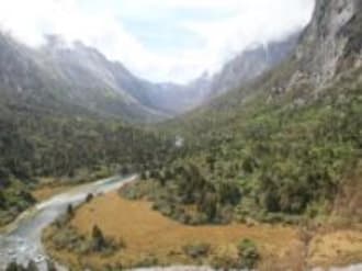
Landing sites are in areas within walking distance of tahr herds and often have reasonably sheltered campsites nearby. At some sites poor weather could prevent aircraft access. Careful planning and weather forecasting is essential. Ensure you have sufficient supplies to cope with delayed pickups. Although the designated landing sites are the only sites where parties may land (some sites have two options), hunters can also walk from these landing sites to their own chosen campsite if they wish. Hunters should be aware of natural hazards such as dead overhanging trees when selecting their campsite. There will be kea at some sites; do not feed kea, and ensure campsites are kept as tidy as possible so as not to attract their attention.
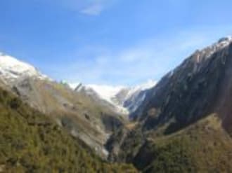
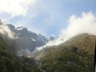
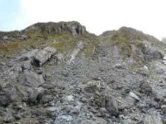
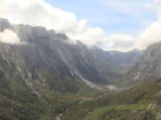
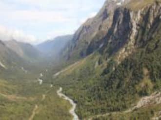
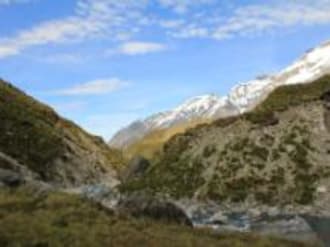
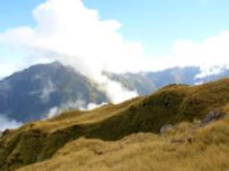
Tahr prefer to inhabit a formidable environment and hunters must be physically and mentally prepared for this. Normal tahr range in summer is from 800 to 2,200 metres; they often seek lower altitude scrub and bluffs during winter. They are usually found on or near steep rocky bluffs. Tahr usually set out to feed in the late afternoon, returning to cover the following morning. Hunting pressure may determine how urgently and how soon after daybreak they do this. Rifles with suitable calibre for shooting at long range are advised, along with good binoculars and spotting scopes.
Aerial operators
The right to fly recreational hunters into these sites will be issued to approved operators. A list of these operators will be sent with your hunting permit. Hunters are free to select a servicing operator from this list. Operators not appearing on the list may not be used.
Aerial-assisted trophy hunting using a helicopter will be permitted in the Wilderness Areas during part of the ballot period. Apart from this, no helicopter wild-animal carcass or live recovery for deer, chamois or tahr is allowed during the ballot period in the Wilderness Areas. If you see any of this happening, record as much information as possible including helicopter registration (numbers and letters displayed on the machine) photos or video footage, and report this to the nearest Department of Conservation office as soon as possible so there can be an investigation.
Check-In Time
Between 2:00 pm and 10:00 pm
Check-Out Time
10:00 am
Reception Hours
8am - 6pm
Payment Policy
Ballot applications not abiding by rules will be withdrawn and party leaders and all party members named on the application will not be considered for the next two years ballot. Payment of $NZ 60 per party ballot application fee is payable at time application is submitted.
All information provided will be used by DOC solely for purposes for which it is gathered in accordance with the Privacy act 2020. By submitting this form the Applicant consents to the disclosure of their name, contact details and the dates of any permits issued to other hunters holding permits who may request this information from DOC for purposes of co-ordinating transport arrangements to and from authorised hunting sites.
A maximum of 6 hunters/ minimum 2 as named on the application and permit may be in the site for the time period allocated.
Party leaders are reminded of their hunting permit conditions, by accepting the right to hunt on a site you agree to abide by the terms and conditions set out in the permit and as Party leader you are responsible for your party members adherence.
Remove all rubbish and camping gear when leaving the area.
All persons hunting must have valid firearms licence.
Only approved aerial concessionaires can be used for aerial access the Wilderness Areas for the balloted period.
No dogs are permitted into wilderness areas.
Hunting during the hours of darkness is prohibited.
To encourage full utilisation of the hunting opportunities, any applicants who do not wish to use their balloted permit are asked to cancel it by contacting Haast Hunting Ballots.
Cancellation Policy
$NZ60 application fee is non refundable.